Severe Storms Possible in Indiana Thursday Night into Friday
STATEWIDE–Severe storms are possible in Indiana on Thursday night into Friday morning.
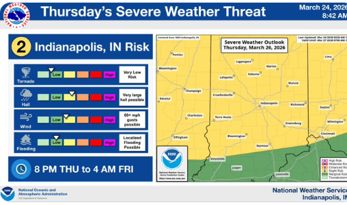
“We’re going to have a cold front that moves in during the evening hours and early overnight. With that cold front, we’re going to see the potential for large hail again during the late evening and early overnight hours,” said Andrew White, meteorologist with the National Weather Service in Indianapolis.
White says most of the threat should end around midnight, but some spots in the southern part of the state might have storms linger into 2 or 3 am on Friday.
“The main threat we’re going to be concerned with is hail initially and then the damaging wind threat will increase gradually as the storms form more into a line across Indiana,” said White.
White believes the threat for tornadoes is low, but it’s always a possibility whenever the severe weather threat ramps up. There have been eight tornadoes so far in Indiana in 2026.
Most of Indiana is under a “slight” risk for severe weather. That means there’s a better chance of seeing a few organized severe storms, and those storms may pack more of a punch compared to lower-risk days. It also means confidence is higher that at least some areas will see storms capable of causing damage.
Hail did move through Indiana on Sunday night.
“In the Indianapolis area and surrounding counties, there were some reports of one inch hail. The largest hailstones were found in the Vincennes area where we had hailstones as big as 1.75 to two inches,” White said.
Severe Storms Possible in Indiana Thursday Night into Friday was originally published on wibc.com